Key Details
Distance and Elevation
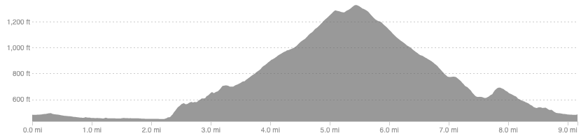
Distance: 9.2 miles / 14.8 km
Elevation: 1005ft / 306m
recommended Footwear
Road shoes will do fine.
Recommended running
Easy time on feet run but you could easily push the pace on the bike path or once onto the forestry roads.
local coffee fix
No 1 has good coffee, cakes, and lunch. Haus and Co has great coffee and a tasty cookie, it is also a home decor shop. Both are in Innerleithen.
Local running shop:
FKT/Segment King:
FKT/Segent Queen:

Route details
Use the park and pedal car parks in Innerleithen, this run is just as good in either direction but I have given the flat portion at the start to allow you to warm up. Pick up the old railway bike path and follow it down river to Walkerburn. Head into Walkerburn and pick up a trail that takes you behind the Caberston Farm coffee shop, signposted for Priesthope hill. Follow the track through the fields and you will eventually get to the forestry tracks.
From here, follow the dirt road back towards Innerleithen. The main track switches back and forth but navigation should be straight forward all the way to Innerleithen golf club. This section of the route is fantastic but be warned, The Golfie is a hotspot for mountain bikers and known all over the world, so be careful on a good weekend because there will be hundreds about. If you wanted to visit the summit and the ruined building en-route then there are a couple of tracks that take you up.
Once down at the golf club you have 2 options. The option above is to follow a single track trail through the woods however, I don’t know if this gets busy with bikes as it is a shared trail with bikes and walkers. The alternative is to follow the road through the golf course that takes you back to the main street in Innerleithen.
Similar alternatives nearby
- Glenbenna horseshoe
- Elibank to Glenbenna
- Minch Moor variations
