Key Details
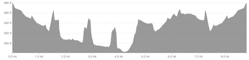
Distance and Elevation
Distance: 8.8 miles / 13.9 km
Elevation: 304ft / 93m
recommended Footwear
Road shoes will be best as a good portion is on tarmac. River tweed path can get slippy if there has been lots of rain.
Recommended running
Easy running but you could push the pace once you leave the river and join the old railway line.
local coffee fix
Zola’s bakery in Galashiels is a fantastic bakery with good coffee and lunch options. Twelve triangles in Melrose does great coffee and baked goods. Apples for Jam in Melrose is good for a breakfast/lunch.
Local running shop:
FKT/Segment King:
FKT/Segment Queen:
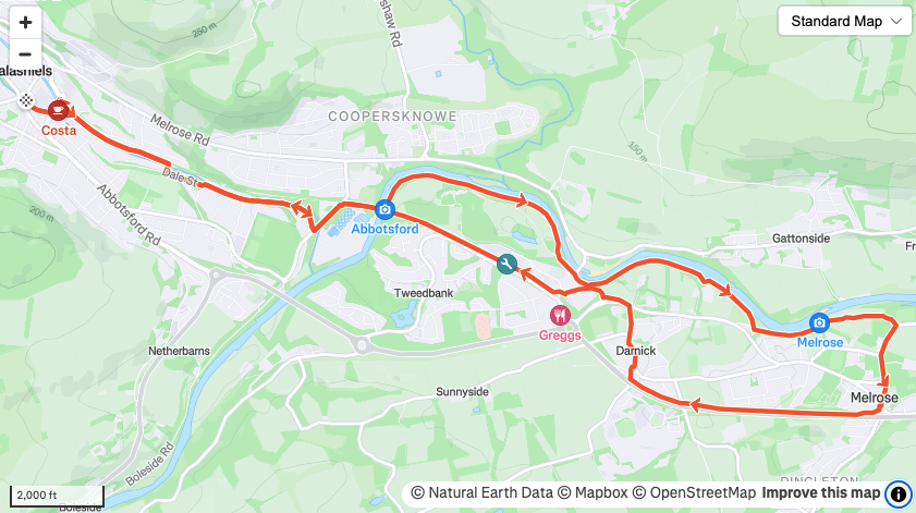
Route details
There is plenty of parking in Galashiels town centre at the supermarkets. Starting from the Reivers memorial head east and pick up the bike path, over the Gala water behind M&S/Tesco. Follow this until the Gala water joins the river Tweed and pass over the railway bridge. Once over the river, drop down the stairs on your right to join the riverside path. Go under the bridge and follow the path as it meanders along the peaceful banks. Keep an eye out for heron as you are bound to see one at some point.
The river side path is following the Southern Upland Way so just follow this until you reach the chain link bridge on the far side of Melrose. At this bridge follow the quiet road east then south towards Melrose Abbey, 1 of 4 historic ruined Abbeys in the Borders. Head up to the main high street and continue south to the old railway station, a quaint feature with preserved advertisements from decades ago. Follow the old railway line back towards Tweedbank station, either through Darnick or following the by-pass, then pick up the railway again back towards your start route out of Gala.
Similar alternatives nearby
- Tweed tour: Abbotsford
- Tweed Tour: St Boswells
- Tweedbank perimeter
