Key Details
Distance and Elevation
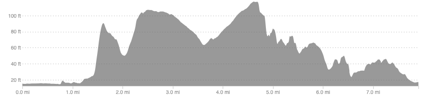
Distance: 7.9 miles / 12.7 km
Elevation: 241ft / 74m
recommended Footwear
Road Shoes.
Recommended running
A flat, pleasant run that mixes up smooth bike paths, grass and woodland trails, and a beach promenade with great views of Arran on a clear day.
local coffee fix
Rocket Monkey are a local roasters that has a scenic location on the promenade last time I visited.
Local Running Shop:
FKT/Segment King:
FKT/Segment Queen:
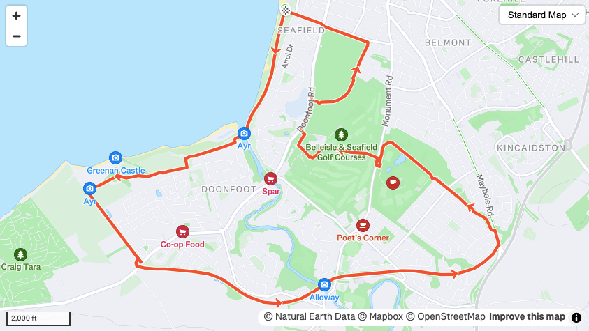
Route details
There is plenty of parking along the sea front so anywhere along there will be fine. Head south along the coast until you pick up the bike path, use the adjacent castle ruins to help direct you if needed. Follow the bike path for around 3 miles until you come out onto Maybole road.
At Maybole road turn left and almost immediately left again to pick up a woodland trail. This will take you to Rozelle park which is a great place to add on a few extra miles if you want to. Follow the perimeter (either direction) to the main entrance and cross over into the golf course. Follow the track through the middle of the golf course to Doonfoot road on the other side. Turn right and cut into the golf course again when it opens out of the trees, picking up a trail behind the stone wall running through the course.
This trail will take you round to the football pitches at Belleise park, which is another great soft surface loop for extra miles or a session. Follow the trail around the perimeter and leave at the opposite corner to where you came onto it. Head down the road to the coast and return to your car.
Similar alternatives nearby
- Ayr Seafront
- Doonfoot bike path
- Belleisle and Rozelle Parks
- River Ayr
