Key Details
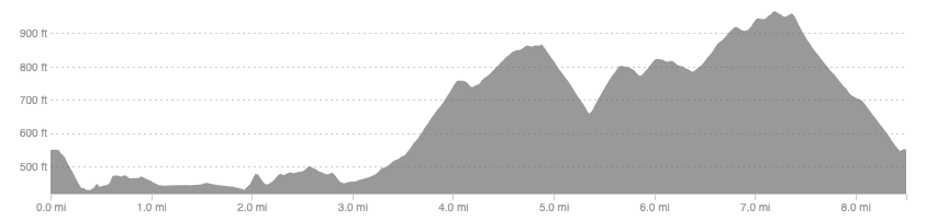
Distance and Elevation
Distance: 8.5 miles / 13.7 km
Elevation: 987ft / 301m
recommended Footwear
Road shoes are fine. Can get a little slippy on the grass by the river but trail shoes wouldn’t make much difference.
Recommended running
Easy running along the river but you could push the pace on the forestry if you wanted.
local coffee fix
No 1 has good coffee, cakes, and lunch. Haus and Co has great coffee and a tasty cookie, it is also a home decor shop. Both are in Innerleithen. Zola’s, in Galashiels, is also a fantastic bakery with good coffee and cakes.
Local running shop:
FKT/Segment King:
FKT/Segment Queen:
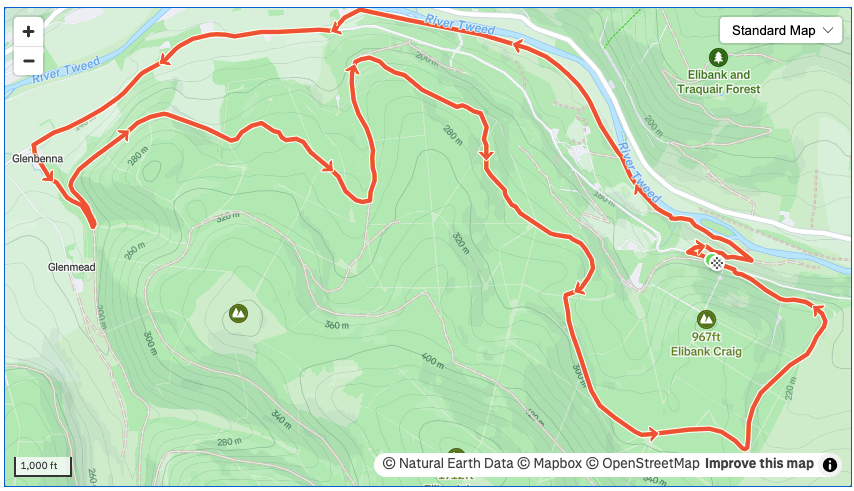
Route details
Park at the entrance to Elibank forest along the backroad between Walkerburn and Innerleithen. Head west and drop down to the Tweed, cutting through a field on a farm track. Follow the Tweed west towards Innerleithen, initially on a dirt road used by fisherman but joining the grassy remnants of the old railway. Around 2 miles in leave the railway to head up to the road. It looks like you are heading in to someone’s garden but the track is fine to follow, just close the gates.
Follow the road now until you get to Glenbenna where you turn onto the forest road and onto the hill. Take a sharp U-turn shortly after joining the track and begin to climb. You will have several long drags up and down as you follow the forestry track back down the Tweed valley, sticking on the forestry that runs parallel to the road and not dropping down onto the tarmac, unless you want to.
This track will take you all the way back to your car. Navigation should be fairly straight forward because any dead end tracks you could follow require you to change direction significantly so just keep heading down the Tweed valley eastward. The only point to be careful is to go left, downhill at 4.8 miles, not uphill, followed by a right to stay on the forestry at 5.3 miles.
Similar alternatives nearby
- Glenbenna horseshoe
- The Golfie
- Minch Moor variations
