Key Details
Distance and Elevation
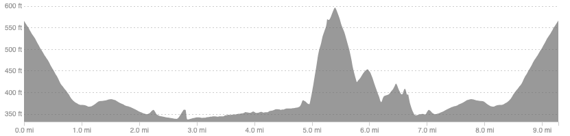
Distance: 9.3 miles / 15 km
Elevation: 642ft / 196m
recommended Footwear
Road shoes. If wet enough to need trail shoes then the riverside path will want to be avoided anyway.
Recommended running
Easy running on a mix of riverside paths, dirt tracks, and quiet country roads. Good for clocking up easy miles.
local coffee fix
Three Hills is a local cafe and roasters in the centre of Selkirk, right by the start/finish of the route. Good coffee and food.
Local running shop:
FKT/Segment King:
FKT/Segment Queen:
Route details
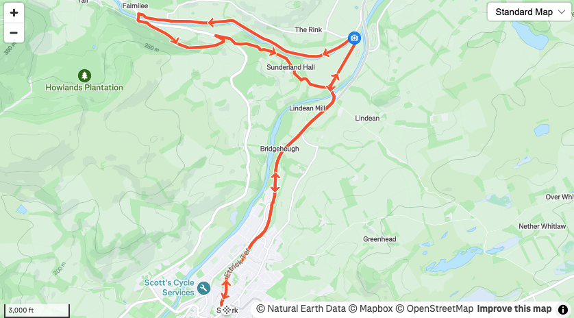
Park in Selkirk town centre and head down the A7, following the bike path all the way to Lindean where you can take the old road to the Old Tweed Bridge. After crossing the bridge drop down the wooden steps and follow the riverside path all the way to Yair bridge. This path can be overgrown in summer but does get mown and after persistent heavy rain you would be better following the road to Yair instead.
Cross over the river at Yair and at the car park follow the trail uphill running parallel to the road. This will join the forestry track and though it adds 200ft of climbing it is much more pleasant than 1km along the road. Once back at the road turn right and then left onto a dirt track through the grounds of Sunderland hall. Follow this track past the hall and back to the old road by Lindean, returning to Selkirk via your outward route.
There are several routes through Sunderland hall so if you miss the first track there are one or two others that take you through further along the road.
Similar alternatives nearby
- Tweed tour: Abbotsford
- Tweed Tour: St Boswells
- Melrose Mondays
