Key Details
Distance and Elevation
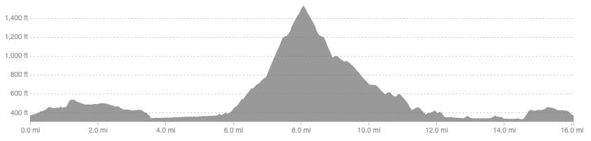
Distance: 16.1 miles / 25.9km
Elevation: 1757ft / 535m
recommended Footwear
Most of this is on tarmac, forestry tracks, or good trails so road shoes are most suited. Trail shoes would only be better if following the Southern Upland Way out of Gala which is a rougher route over the fields.
Recommended running
A classic time on feet route for an easy, albeit long, run in the hills. Plod along, take in the views, enjoy the descent.
local coffee fix
Zola’s in Galashiels gives a solid coffee and a fantastic selection of cakes, pastries, cookies, and lunch options. It is also happens to be a plant based cafe but you would not know if you hadn’t been told.
Local running shop:
FKT/Segment King:
FKT/Segment Queen:
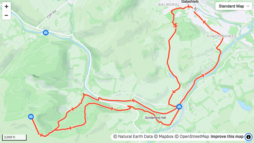
Route details
Park at Tesco in Galashiels where there is 3 hours free parking (you may want to find a quiet street or use the charged car parks in town if you plan to be out for longer than this to avoid the fine). Head uphill towards Scott park and the Gala policies. Either follow the mapped route or just follow the southern upland way the the fields and back road on the other side. Follow the quiet country road all the way over to the river Tweed. There is the possibility to head over the fields on the Southern Upland Way and rejoin the described route at Yair bridge. The SUW is runnable but is rougher underfoot, adds elevation, add could get muddy when wet.
Once you join the road over the river Tweed, turn left downhill to the Old Tweed Bridge, a charming old stone bridge and possible start point if you wanted a 10-12 mile option, and follow the wooden steps down onto the north banks of the river. From here you have 2 miles following the Tweed up to another old stone bridge, Yair bridge, running on good grass paths and dirt farm tracks.
At Yair bridge cross the river and continue north. If you wanted a shorter route you park here and return to your car once back at the road instead of heading to Sunderland hall, giving a 6-7 mile route. Keep an eye out a few hundred metres up near the houses for the sign indicating the Southern Upland Way and follow it. From here there is significant, but still runnable climbing for around a mile. After this first mile you cross a couple of forestry tracks and the trail does steepen considerably, becoming a real quad burner at times. After half a mile of this you will break out of the trees, hopefully getting good views to the hills visible from Selkirk town centre. Continue to follow the SUW to the three large summit cairns and enjoy a panoramic view before re-tracing your steps. At the first forestry track turn right and leave the SUW. Follow this main track all the way down to the road on a fast and gradual descent.
Turn right at the road and run on it for three quarters of a mile before following a rocky dirt track by a cottage. This takes you into Sunderland hall which will take you to the A7. From here you can take the bike path all the way back to Gala or follow the map above and follow the grassy banks of the tweed to stay off tarmac. At the first chance you get leave the river/bike path to head up the the A7 again, following the main road and SUW signs back to town for a coffee and pain au chocolat at Zola’s.
Similar alternatives nearby
- A bridge for a Brethren
- Craig Contour
- The Eildons
